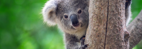
Koala protection projects
Federal Koala Grant completion
Under a 3 year grant project, our Natural Systems team has delivered multiple positive outcomes for the Koala population in Port Stephens. The most significant project outcomes or contributions of this grant included:
Re-defining Koala Habitat in Port Stephens: Aimed to define koala habitats through collaboration with the Department of Planning and Environment. A methodology for identifying koala habitat was developed with the NSW Koala Strategy Team, resulting in an expanded list of koala feed tree species from 3 to 18. This updated list will enhance the representation of koala habitats across different vegetation types in Port Stephens. It will directly inform updated koala habitat mapping, which is set to be completed by December 2026. The new tree species list will also be included in our Development Control Plan for development approvals.
Vegetation Mapping Stage: The project produced three stages of detailed vegetation maps for the Port Stephens LGA. Stage 1, which covered the eastern part of the LGA, was delivered as a final draft in October 2024. Stage 2, focusing on the central region and funded by a grant, was completed in February 2025. Stage 3 is scheduled for delivery in December 2025. The comprehensive final vegetation map will be available to the public by January 2026, with interim updated maps guiding development and land planning decisions.
Identification of Key Corridor Links for Rehabilitation: This initiative overlapped existing habitat connectivity maps with the koala habitat map to identify priority areas for rehabilitation. Using these maps, we developed a koala habitat restoration priority map in consultation with the NSW Koala Strategy Team. We aligned it with the draft Northern NSW Regional Koala Conservation Strategy. The map categorises areas into five categories for protecting, maintaining, restoring, and creating koala habitats. This collaborative approach has engaged major landholders in koala habitat restoration efforts across the LGA.
Faecal Sampling: Included collecting koala scats as part of the drone survey research conducted by the University of Newcastle. On-ground validation of koala thermal signatures was necessary, and scat collection occurred during these drone surveys across the LGA to gather samples from known or suspected local sub-populations of koalas.
Vegetation and Koala habitat mapping
We've received State and Federal Government funding to prepare updated vegetation mapping and koala habitat mapping for Port Stephens. Detailed vegetation mapping provides vital information to help inform land mangers, like Council, ensure land management actions are appropriate, and assists in the identification of important vegetation in Port Stephens.
We'll be undertaking the vegetation mapping in 3 stages, with the results made publicly available once complete.
Following vegetation mapping we'll also be undertaking additional surveys for Koalas across the Port Stephens to determine where Koalas are present.
This vegetation mapping coupled with the koala occupancy surveys, will be used by the NSW Koala Strategy’s team of koala scientists to prepare a new koala habitat map for Port Stephens.
Current Koala Habitat Map
Council has heard the suggestions of the community and a simplified Koala Habitat map has recently been completed. The new map consolidates Council's Koala Habitat Maps into one layer, and features different colours to identify what type of habitat you're viewing. The interactive map will allow ease of investigation alongside other development constraints, and the ability to zoom into parcels.
View the current Koala Habitat Map
Culturally informed cool burn to improve Koala habitat connectivity
Learn about the culturally informed cool burn we undertook in partnership with Worimi Local Aboriginal Land Council, Bindelong Indigenous Aboriginal Corporation and Hunter Local Land Services.
A cool burn, also known as a low-intensity burn, is a controlled burning technique designed to remove undergrowth and dry debris without significantly impacting the overstory vegetation.
The cool burns, which took place at Salamander Bay and Mallabula in August and October 2025, offered significant cultural and environmental outcomes, including enhancing koala habitat, reducing bushfire fuel loads, and strengthening collaborative relationships.
This project was made possible through grant funding from the NSW Government’s Environmental Trust ‘Caring for Country’ grant.

Port Stephens Drive Koala Vehicle Strike Project
The Port Stephens Drive Koala Vehicle Strike Project delivered in partnership with the NSW Koala Program, aims to reduce Koala fatalities along one of the worst Koala road-strike locations in NSW. During a 10 year period between 2010-2020 a total of 89 Koalas fatalities were reported along Port Stephens Drive.
The area was identified as a blackspot under the NSW Koala Program with this project initiated to reduce the number of Koala deaths and injuries.
Download the Port Stephens Drive Koala Monitoring Report 2023-2025 (PDF 1.9 MB)
MidCoast and Port Stephens Koala Conservation Partnership
The NSW Government is funding a Regional Koala Conservation Partnership under the NSW Koala Strategy, with funding being provided to the MidCoast and Port Stephens region for Koala habitat restoration, vehicle strike mitigation, and to develop Koala habitat maps and Koala monitoring. Find out more about the partnership through the video link below:
University of Newcastle Drone Project
Council is currently working with conservation scientists from the University of Newcastle who are using heat-detecting drones to capture data on Koala populations in Port Stephens LGA. The data will assist scientists in creating a model to better predict Koala numbers across vast landscape and provide clues on how to best manage koala populations.
For more details on this project, view the University of Newcastle's latest media release: